APLIS POSTCARD #7
18 March 2007
Position: 73-07N/145-45W
Temperature: -11ºF
Greetings from APLIS, adrift in the Arctic Ocean. More precisely, the Beaufort Sea, as this
part of the Arctic is known. The pack
ice here in the far north is constantly in motion but our little part of it has
been essentially stationary for the last several days. Then today we started drifting again - a
whopping half-mile in the last 24 hours.
After spending the night hosting the VIP party, ALEXANDRIA
surfaced this morning to allow them to debark.
The VIPs, still in high spirits, passed through APLIS for a quick snack
before boarding the planes to take them back to Prudhoe Bay. But they stayed long enough to sample some
good camp food and to visit with Bruno, the APLIS mascot.
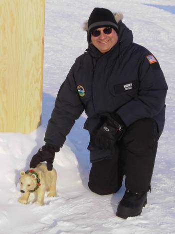
Secretary of the Navy Donald Winter
with Bruno, the APLIS Mascot
While ALEX was entertaining the VIPs, TIRELESS continued her
test programme. She spent the night and
most of the morning testing the high-latitude performance of new navigation
systems she has aboard.
Submarines operating in the Arctic face two navigational
challenges not normally encountered by ships at sea.
Nowadays, most ships (along with many cars) use GPS
satellite information to update their location. But when a submarine is operating submerged with a layer of ice
overhead, it has no access to GPS signals.
As a result, submarines up here are almost entirely dependent on Ship’s
Inertial Navigation Systems (SINS) to keep track of their location. The only way to update their SINS is to
surface to obtain a GPS fix. TIRELESS
has the new NATO SINS system on board which is one of the items being tested.
The second challenge for anybody navigating in the polar
regions stems from basic geography. We
have delineated the world with lines of latitude (running east-west) and
longitude (running north-south). Down
in the lower latitudes where you are, these longitude lines are roughly parallel
to each other and cross the latitude lines at right angles. But up here, the longitude lines all start
to converge at the North Pole and the latitude lines turn into circles. The closer you approach the North Pole, the
more that normal navigation conventions start to fall apart. For instance, near the pole you might start walking
east and, if you continue in a straight line, find out that you’re heading
nearly south.
Our submarines’ inertial navigation systems can remedy
this. Using software, we can lie to the
system about the location of the North Pole, allowing them to work in a
completely different system of latitude and longitude, called the polar
transverse system. The NATO SINS
ability to function in this mode will be evaluated as TIRELESS transits back
across the Arctic after leaving APLIS.
Ok, enough technology talk.
One of the many unique things about the Arctic region is the Aurora
Borealis, or northern lights. This
wavering green light in the night sky is caused by the interaction between
solar wind and the earth’s magnetic field.
Because the earth’s magnetic field is so concentrated here in the far
north, we see the effect frequently.
Whoops, technology talk again.
Anyway, the lights have been out and beautiful almost every night since
we arrived. Here’s a sample, courtesy
of Barny Revill, part of the UK documentary crew from Tigress Productions.
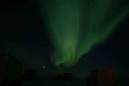
Sweet Borealis Dreams to you all.
Jeff Gossett
Arctic Submarine Laboratory