APLIS POSTCARD #8
19 March 2007
Position:
73-10N/145-50W
Temperature: -12ºF
Greetings from APLIS, adrift in the Arctic Ocean.
As I said yesterday, the ice is nearly constantly in
motion. Overall, in this region of the
Beaufort Sea, we expect to move west or northwest. But that doesn’t mean that motion is always in that
direction. During the first 2 weeks of
camp buildup, the floe on which APLIS is located oscillated east-west along a
line about 20 nm wide. At any given
time, motion is based on winds acting over hundreds of square miles of ice,
currents, and residual motion from previous days. The most important thing to keep in mind is that we have
absolutely no control over where we go.
Today I’ll talk about some of the science work that we’re
doing here.
We have two graduate students from
the Naval Postgraduate School in Monterrey, CA here at APLIS doing thesis
research. LT John Bleidorn and LT Tim
McGeehan are making use of our location on the ice to study under-ice
oceanography. I’ll let them explain the
experiment for themselves.
We will be using sonar to image an underwater ice keel and
then measure the turbulent wake behind it.
We hope this data will improve models which describe the complex interactions
between the atmosphere, sea ice, and ocean.
To get their instruments in the
water, they found a location that appeared to be adjacent to an ice keel. When the ice deforms into ridges, there is a
corresponding above-ice feature, or ridge.
Just outside camp was just such a ridge so they set up their study area
on the flat ice adjacent to the ridge and started melting a hole.
NPS Tent and their Ice Ridge
We intentionally chose to locate our camp on a floe that’s
several years old - older means thicker and more stable. But it also means that, after a couple
summers of surface melting and years of being exposed to the erosive effects of
the wind, ridges can be worn down while the keels beeath them survive.
That’s what happened here.
After two days of melting, they finally broke through to the ocean -
through 40 feet of ice! They didn’t
melt next to the keel, they melted through it.
Anyway, today they are starting to install their instrumentation. I’ll provide some of the results as they come
in.
But that’s not the only science that we’re doing. I’ve mentioned before that we’re going to
turn the camp over to the National Science Foundation after we’re done with our
work. The major thrust of that camp
will be to study various aspects of ice mechanics. They have asked if we could install some of their instruments
during our camp in order to monitor the movement and evolution of ice in our
area. Their highest priority is for us
to install a ring of instruments circling the camp at a radius of about 6
nm. We’ve wanted to install these
before now but the helicopter has been tied up with four straight days of
surfacings.
Today we finally had our chance. Randy Ray (our ubiquitous Field Operations Coordinator), assisted
by Doug Anderson (from ASL) and LtCdr Stuart Capes (one of our RSOs) set out
this afternoon and got all 6 buoys installed in just a couple hours. Here’s what they look like.
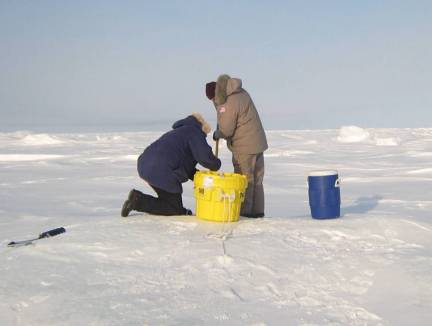
Randy Ray and Stuart Capes
Installing a GPS Buoy
In the first postcard, I said that I’d talk about our furry
neighbors but you may have noticed that I haven’t mentioned them so far. There’s a reason for that - we haven’t seen
any. At least, until yesterday. On their way back to Prudhoe Bay yesterday
afternoon, the VIPs spotted a mother and cub, about 100 miles to the south,
headed this way. Only a matter of time
now.
Jeff Gossett
Arctic Submarine Laboratory